Day 04 · Clusters · Research PoC
Shared destinations
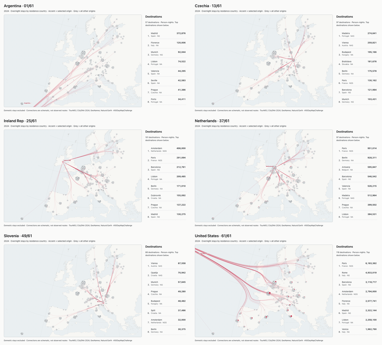
Every origin, together. Each bubble is a country’s overnight stays in one destination. Cities pull their bubbles together; choose an origin to trace its footprint. The map is framed by Madeira, Trondheim and Rēzekne.
Loading local data…
Bubble area ≈ person-nights · Accent = selected origin · Tiny dark dots = destination attractors · Lambert azimuthal equal-area projection
Frame: Madeira → Trondheim → Rēzekne. Destinations outside this frame are omitted from the map and ranking.
Bubbles are displaced for legibility, not additional travel locations. Hover a bubble or select a ranked destination to show its anchor.
Cities as attractors
These are geographic bubble clusters, not country colours or statistical visitor segments. All source countries remain on the map when the source selection changes. The domestic-stay toggle hides every pair whose origin and destination countries match, not just the selected origin. Changing this filter loads a separately precomputed layout without the excluded bubbles; changing only the source keeps positions fixed. The size scale stays fixed in both cases. Each destination attracts its own origin bubbles, while a collision force separates neighbouring bubbles. Dense clusters can spill away from the exact city point.
Coverage, method & sources
This is a selected-destination PoC, not a complete ranking of Europe. TourMIS contains 154 reporting destinations in this extract, including Madeira and Tel Aviv. Blank cells are unknown, not zero. No missing counts are estimated.
One bubble is drawn for every non-missing individual-country × destination count within the map frame. Continents, foreign/domestic totals and residual “Other” groups are excluded to avoid double counting. Reported zeros remain present at the minimum marker size; missing values are not invented. Domestic stays can be included by unchecking the filter. This view does not use the earlier eight-market statistical clusters.
Both layouts are simulated once during preparation and stored as coordinates. Rendering, resizing and filtering never run a force simulation. Layout inspired by D3’s Clustered Bubbles: fixed city-coordinate attraction replaces free-moving group centroids, with D3 collision forces. The layout and area scale are independent of source selection; tiny values use a disclosed minimum radius. Hover or select a bubble to reveal a line to its true destination anchor. The selected-source list provides keyboard access.
Connections use an offline geographic hierarchy: eight direction sectors, recursive spatial splits, and shared control points rendered with D3’s bundle curve. Only the selected source is drawn. Country points come from GeoNames capital/seat records (largest population where several exist); Israel uses Tel Aviv as an explicit representative-city fallback, not a capital claim. These are country proxies, not observed origins. Representative source points outside the viewport retain their true projected coordinates. Their lines are clipped; only a directional country label is placed at the edge. This does not mean the entire country is outside the map. Zero counts have no connection line. No roads, flights, transit hubs or observed routes are implied.
TourMIS “preferred definitions” mix hotels with all paid accommodation, and city with greater-city areas. Overlapping reporting areas must not be added together. Bednights measure person-nights, not unique travellers. Overseas markets remain valid origins; Madeira and Tel Aviv are reporting destinations in the extract.
Data: extracted/adapted from TourMIS / CityDNA, ECM-J8, annual 2024, retrieved 4 November 2026. © MU Vienna and contributing statistical providers. Reuse terms. Individual provider attribution remains to be verified before treating this research PoC as publication-ready.
Coordinates: GeoNames, CC BY 4.0. Madeira uses Funchal and Haarlemmermeer uses Hoofddorp as representative points. Land: Natural Earth, public domain. Projection: Europe-centred Lambert azimuthal equal-area, centred at 10°E, 49°N (D3’s spherical model; not an exact EPSG:3035 transformation). Local D3 v4, BSD-3-Clause. Substantial AI assistance: data extraction, geocoding, clustering, implementation and checks.
Download adapted TourMIS CSV · Animated country tour (GIF) · Preparation and limitations